


 Glacial Lake Hitchcock was formed behind a giant earthen dam at Rocky Hill, Connecticut about 15,000 years ago. Before it drained away about 3,000 years later it had reshaped the valley for almost two hundred miles upstream. (Map Umass Geoscience)
  The mill pictured above and the two below are typical of the many mills located on the streams, rivers and lake outlets of the region. The one above is the Sanborn mill established in1876 on the Grant Brook in Lyme Center. (Lyme Historians)
 The dam on this Lyme mill is a log dam. Logs of this type were hauled to tanneries
and the bark was used for hide processing. (Lyme Historians)
 This tannery was established in 1846 by S. W. Balch and is located
 The falls at Boltonville on the Wells River was one of the significant sources of hydropower in the area. The river falls about 60 feet in a distance of about 130 feet. The first mill was build at this site in 1775 by the Scots-American Company of Ryegate.

There were three log or timber dams on the falls of the Waits River in Bradford. Pictured above is a repair crew working on the flume that leads to one of the factories near the second falls (c. 1880's) Bradford Historical Society
 The Comerford Dam in North Monroe/East Barnet was constructed between 1928 and 1930. Up to 2700 men worked on the project, with crews working around the clock. A village was created to house and feed the men.
 The completed Comerford dam was the first stage in the development of the
Fifteen Mile Falls area of the Connecticut River
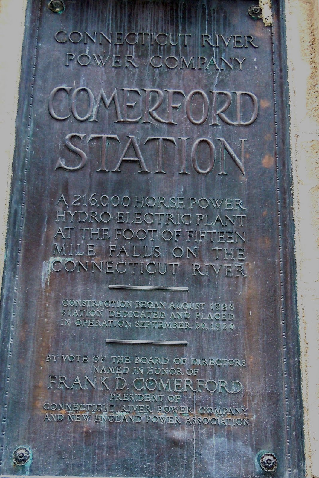
 This bronze plaque recalls that the dam was named in honor of Frank D. Comerford,
President of the New England Power Associaton at the time of its construction. These next photos were on Wednesday, Sept.15, 2010 during a tour of the dam. Staff member ScottFullam, Control Technician, was my very helpful tour guide.
 "The Button"
In the lobby of the Cumerford Dam power station is mounted the button President Hoover pushed to activate the dam. The inscription reads: "By pressing this button, set up in the telegraph room of the White House in Washington, Herbert Hoover, President of the United
States , at 10:30 A.M. on September 30, 1930, placed Cumerford Station in operation. The impulse from the President's finger, traveling 700 miles over a special telephone circuit, opened the turbine gates and set no. 2 generator in operation."
 This is the channel in the Connecticut River downstream from the Comerford dam.
 The downstream face of the dam shows the "jersey barrier" type
supports that hold the dam in place.

 This tannery was established in 1846 by S. W. Balch and is located
on Grant Brook in Lyme. (Lyme Historians)
 The falls at Boltonville on the Wells River was one of the significant sources of hydropower in the area. The river falls about 60 feet in a distance of about 130 feet. The first mill was build at this site in 1775 by the Scots-American Company of Ryegate.

There were three log or timber dams on the falls of the Waits River in Bradford. Pictured above is a repair crew working on the flume that leads to one of the factories near the second falls (c. 1880's) Bradford Historical Society
 The Comerford Dam in North Monroe/East Barnet was constructed between 1928 and 1930. Up to 2700 men worked on the project, with crews working around the clock. A village was created to house and feed the men.
 The completed Comerford dam was the first stage in the development of the
Fifteen Mile Falls area of the Connecticut River
 This bronze plaque recalls that the dam was named in honor of Frank D. Comerford,
President of the New England Power Associaton at the time of its construction. These next photos were on Wednesday, Sept.15, 2010 during a tour of the dam. Staff member ScottFullam, Control Technician, was my very helpful tour guide.
 "The Button"
In the lobby of the Cumerford Dam power station is mounted the button President Hoover pushed to activate the dam. The inscription reads: "By pressing this button, set up in the telegraph room of the White House in Washington, Herbert Hoover, President of the United
States , at 10:30 A.M. on September 30, 1930, placed Cumerford Station in operation. The impulse from the President's finger, traveling 700 miles over a special telephone circuit, opened the turbine gates and set no. 2 generator in operation."
 This is the channel in the Connecticut River downstream from the Comerford dam.
 The downstream face of the dam shows the "jersey barrier" type
supports that hold the dam in place.

As printed in Journal-Opinion
September 15, 2010.
Fifteen thousand years ago, the retreating glaciers deposited a giant dam near Rocky Hill, Connecticut. A huge lake, known as Lake Hitchcock, extended 200 miles up the river to present-day St. Johnsbury. By the time the dam gave way about 12,000 years ago, it had given a new shape and fertility to the Connecticut River Valley.
Within the heritage of the Abenaki, who peopled this valley before the coming of the Europeans, are legends of Odzihozo, the earth-shaper and Ktsi Amiskw, the Great Beaver.
This Great Beaver held back the waters of the Kwanitekw, or the Connecticut. But a cousin of Odzihozo broke the back of the beaver and released the captive waters.
On September 30, 1930, President Herbert Hoover pressed a button in the White House and one of the turbines in a newly-constructed dam on the Connecticut River between East Barnet and North Monroe began to produce electricity that was sent to southern New England.
On Saturday, September 18, the Third Annual Local Energy Alternatives Festival will be held in Bradford. Organized by the Energy Committee of the Bradford Conservation Commission along with others, it will be dedicated to, “renewable energy, sustainable living, local food production, transition to a world without oil and re-skilling.” A tour of the hydro-electric station at the dam on the Waits River is just one of the activities.
Taking its lead from these four events, this column deals with the history of dams in our area. In addition to standard local histories, it takes information from Where the Great River Rises, published by the Connecticut River Joint Commissions and From the Rivers by John T. Landry and Jeffrey L. Cruikshank.
Runoff from ample rainfall flows down the rocky foothills of the Green and White Mountains into the valley, creating rapidly flowing streams and numerous waterfalls. Ponds and lakes release their overflows down outlets to rivers into the Connecticut. Where hydropower was created by flowing and falling waters, the earliest settlers established their homes. The building of mills to grind grain and saw lumber was of primary importance.
For many of these mills, dams enhanced the available power. Some of these were rudimentary dams that sometimes didn’t survive the spring freshets. Others were stout wooden frameworks of logs or timbers filled with earth and stone. Where there were rock outcrops, these dams might be secured by iron spikes. Norman Smith’s History of Dams explains that the upstream wall might be sloped, “causing the pressure of the water to stabilize the dam and hold the facing materials in place…the air face was vertical so that the overflow fell straight.”
Some dams operated on a “store-and-release” principle, storing water until it was needed. Other mills operated with natural flow or “run-of-the river” design. In many cases, the mills were “high water mills” that operated only portions of the year. Dams on navigated rivers had to “include canals and locks for passage of lumber and farm products.” Water was transferred to a mill’s waterwheel by a sluice or canal to a gate that regulated the flow.
The power of the rushing or falling water was harnessed by means of waterwheels. “Protruding boards on these wheels, called ‘buckets,’ caught the downward pressure of waterfalls, turning the wheel and rotating the attached power shaft.” Wheels were of different designs with water being caught at the top, middle or bottom of the wheel.
Each town’s local history chronicles the many mills and dams located on the lakes, rivers
and streams of its community. There were as many as 50 water wheels on the Ompompanoosuc and its tributaries. At one time or another, there were a similar number on Jacob’s Brook in Orford. Wherever there was flowing water, small industrial sites developed.
Some of these include Post Mills and the other villages of Thetford, Waits River and the other villages of Topsham, East Corinth, East Ryegate, Wells River and the other valley villages of Newbury, Woodsville and the other villages of Haverhill and all along the brooks of Lyme, Piermont and Orford.
Dams were also located at the outlets on lakes such as Lake Fairlee, Morey, Tarleton and Ricke and Halls as well as Ticklenaked Pond. In addition to providing power for mills, these dams regulated the level of the lakes. Many lakes and ponds still rely on dams for that purpose.
In addition to grist and saw mills, the early water wheels ground clover and linseeds for oil; turned lathes that fashioned chairs and bobbins; powered machines that made fishing poles, paper, shingles, boxes and clothes pins. They pressed fruit for cider and jelly. Electricity was generated at Woodsville on the Ammonoosuc and at Thetford Center at the Great Falls of the Ompompanoosuc.
The falls in the Waits River at Bradford and the Boltonville Falls on the Wells River have been two of the most significant sites for power production on tributaries of the Connecticut. The first mills at Boltonville were built in 1775 by the Scots-American Company of Ryegate. Katharine Blaisdell’s Over the River and Through the Years describes the development of the river, which, at Boltonville, falls about 60 feet in a distance of about 130 feet. In 1909, the Ryegate Light and Power Company built a power plant at the foot of the second falls. Damaged by the 1927 flood, the dam was repaired and continued operation until the 1950’s, when the plant was severely damaged by lightning.
In 1772, John Peters built the first mill at the falls in Bradford. It was a grist mill
located just south of the Route 5 bridge. Two years later, Benjamin Baldwin built a sawmill at the third falls near the present Bradford Veneer and Panel Company. In 1847, Asa Low built the brick grist mill that stands at the entrance to Bradford village. Other mills, including Low’s large paper mill, stood on the west side of the river and used water from three dams to power their machines.
At the1847 grist mill, the water was carried from the fall by a wooden flume under the bridge into the basement of the mill. The water turned a large water wheel and then returned to the river. The interior location, common in many northern mills, prevented the wheel from freezing in cold weather. In 1897, the Bradford Electric Light Company began to use the old gristmill for the production of electricity and in 1902, built a stone arch dam at the middle falls. This dam was built from cut stones remaining from Low’s destroyed paper mill. The height of the dam was raised in 1921 with a 16-foot concrete section.
In 1972, the hydroelectric dam had become silted and damage to the main turbine caused the plant to be closed. In August, 1981, Central Vermont Power Company spent $3.5 million to rebuild the dam and powerhouse. Presently, it has the capacity to produce 1,500 kilowatt-hours of generated electricity. One of the activities of Saturday’s LEAF Festival will be a tour of the adjacent power station.
As has been stated before, on September 30, 1930, what is now known as the Comerford Dam in North Monroe was officially set into operation. Begun in 1928, the project employed up to 2,700 men, with crews working around the clock. It was built in cooperation with the New England Power Association which had begun to acquire land and water rights on both sides of the river several years earlier.
United Opinion articles at the time described the dam as “the largest hydro-electric plant ever built in New England.” It was the first phase of the mammoth Fifteen Mile Falls development, and it rose 175 feet above the river bed and stretched 2,253 feet from shore to shore. It had the largest concrete retaining wall ever built in the United States and each of its four turbines were capable of developing 54,000 horsepower of electricity. The electricity was sent by newly-constructed steel tower lines to Massachusetts, thus saving an estimated 200,000 tons of coal annually.
President Hoover’s role was particularly appropriate because, as Secretary of Commerce and chairman of a special government commission that was studying the “super-power” resources of the northeastern section of the country, he had visited New England. The commission’s report highlighted the need to develop the hydroelectric potential of the Connecticut generally and the Fifteen Mile Falls specifically. In that section of the Connecticut, the river drops 367 feet in elevation and, “for centuries the 400,000 horse power… was running wastefully to the sea.”
The other two dams in the Fifteen Mile Falls project are the McIndoes Station in Monroe, completed in 1931, and the Moore Station in 1957. The latter is located south of Littleton, N.H, and is the largest of the three with an output of 190,000 kilowatts. Together the three dams “comprise the largest hydroelectric generating complex in New England.”
The last significant project on the Connecticut in our region was the rebuilding of Wilder Dam(1950-1952) at the Wilder Falls. The first dam was built in 1882, slightly north at the Olcott Falls. That dam was of timber-crib construction with a concrete dam added in 1926. It had initially been built to supply water power to a paper mill, with hydroelectricity capacity added later. The mill closed in 1927.
A new dam was proposed in 1944, but local opponents such as Henry W. Keyes Jr. of North Haverhill, fought its construction in a protracted legal battle. They pointed out that the increased height of the proposed dam, and the resulting lake, would flood thousands of acres of prime farmland. Despite these concerns, some of which have proven accurate, the dam was completed. Prior to the construction of the dam, one could see the middle rock base for the Fairlee-Orford covered bridge as a small island south of the present bridge. As a result of the higher level of water, it no longer can be seen even in the most prolonged drought. The resulting lake with its flood control capability has made possible riverside homes and river recreation unknown in the 1950’s. In 2017, all four of these modern dams were purchased by Boston-based Great River Hydro from TransCanada Hydro Northeast. The State of Vermont had looked into buying 13 hydroelectric stations from TransCanada by ArcLight Capital Partners, owners of Great River was more aggressive in their bidding.
Following the devastating floods of 1927 and 1936, a different type of dam was built.
Specifically designed for flood-control, they remain generally empty during most of the time. Three such dams are the ones at East Barre, Union Village and North Hartland.
The mighty dams on the Connecticut are the modern descendants of the mammoth glacial dam of Lake Hitchcock and, perhaps, even the giant dam created by the legendary Great Beaver. With their huge artificial mounds of rock, flooded acres and altered riverbanks, they are like Odzihozo, the earth-shaper. Dams have created the industrial and recreational bases of towns and villages throughout our region and continue to give electrical lifeblood to our modern way of life. Water controlled behind dams throughout the valley means a constant supply of drinking water for people and animals and water with which to fight fires. The water that would otherwise flood homes is held in check.
The power from the hydroelectric dams free industry from being located only on the banks of rivers and streams. Whether small or large, whether the water released from them turn waterwheels or turbines, they represent the renewable energy being celebrated by the LEAF Festival this weekend. For nearly 250 years, dams have taken the power of rushing water, increased its natural power and used it over and over again as it flows to the sea.
